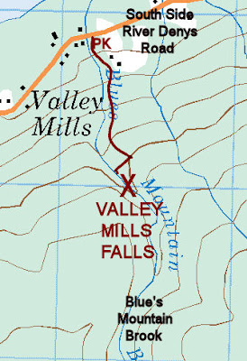
Valley Mills. Inverness County
45N50.651 61W06.209
20T E647262 N5078484
RIVER: Blue Mountain Brook
CLASS: plunge
SIZE: 10', 30'
RATING: excellent (***)
TRAIL: old woods road
DISTANCE: 400m
HIKING TIME: 30min
CONDITIONS: moderate
Geocache: GC1VHZZ
NS Atlas Page: 22/Y4
NS topo map: 011F14 (Whycocomagh)
DRIVING DIRECTIONS: from Port Hawkesbury, follow HWY1 05 north
from Port Hastings, 31 km to Exit3 at Melford. Follow Northside
River Denys Road 2km until Southside River Denys Road splits
off from it. Follow the south road 1 3km, through the settlement of
River Denys at the crossroads, until you reach Valley Mills. Park
on the far side of the bridge over Blue's Mountain Brook.
photo ICCNS
Trail Description: an old driveway leads uphill past an
abandoned trailer and into the woods on the lefthand side of the
brook. Follow this up to old mill ruins, and then hike down into
the gully to the base of the lower falls. Climb over these to view
the main falls.
The old millsite here, with in situ grist mill stones and tall
standing drystone walls, was built by Dougal 'The Miller' Blue,
who operated the mill powered by the falls. His son Kenneth
later continued the tradition and was the last person to operate
the mills. The falls here are also called Blue's Falls in his honour.


i'm glad you have these pictures of the old mill,someone went in and stole all the round stones
ReplyDeletethere is still half of one of the millstones there. so, maybe they didn't steal them - just vandalized them.
ReplyDeleteYes, they were stolen. It broke our hearts. Someone brought in machines and cut out a trail and took them. This is private land I shared with my siblings. It is now owned by my brother. It is private property and not a tourist attraction. I am shocked to find this advertised as a place to visit with a map and directions included. Imagine I drew a map to your family property and encouraged people to tour around. There are plenty of Blue relatives nearby...we could have easily been located. Something like this should not be posted without contacting the property owners.
ReplyDeletei invite you to read the relevant legislation which codifies crown ownership of all waterways and features in the province, along with the angling act which permits access to any watercourse by public entities in the province. while the theft and vandalism is regrettable, these instructions and future waterfall pages will include this site's coordinates and hiking directions. i discovered valley mills falls through a still active geocache at the site. (https://www.geocaching.com/geocache/GC1VHZZ_valley-mill-falls) that has been active a full decade. sorry that you are shocked, but educate yourself on the legislation before you get TOO offended, because you wont come out of this argument the winner.
DeleteRR#2 Valley Mills farm, generations of Blues - my family’s land (150-200 acres), a childhood memory. The house, outbuildings and barn near this trout brook and falls. The brook(river) powered the grist mill. The family became primarily farmers, my dad included. The abandoned trailer may have been a cousin’s, who as a retired “Mountie” RCMP planned to restore the ancient farmhouse but instead somehow managed to burn it down.
ReplyDelete