Tuesday 25 June 2013

SULLIVAN VAULT BROOK FALLS

SULLIVAN VAULT BROOK FALLS
Halls Harbour, Kings County
N 45° 10.985 W 064° 38.257 
UTM: 20T E 371343 N 5004593


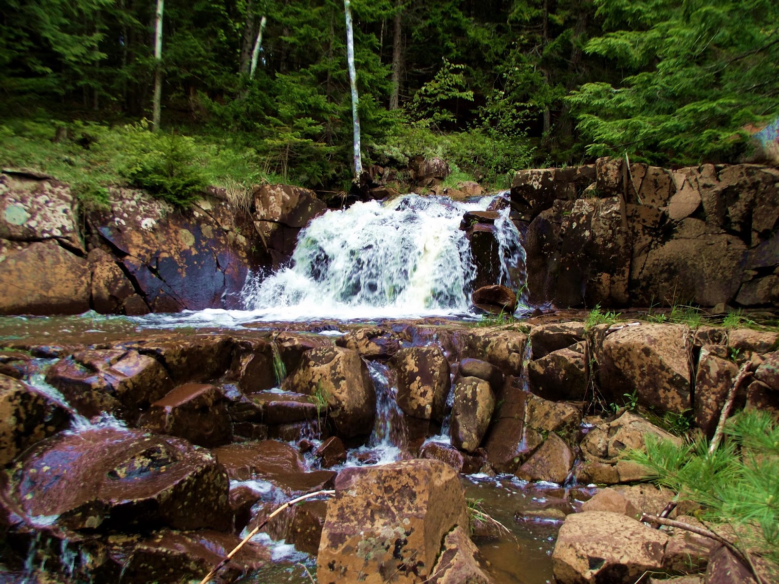
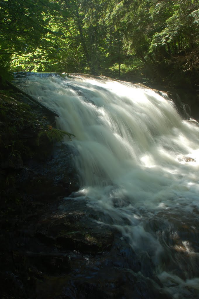
RIVER: Sullivan Vault Brook
CLASS: cascades
SIZE: , 15'
RATING: average (***)

TRAIL: footpath
DISTANCE: 120m
HIKING TIME: 10 minutes
CONDITIONS: moderate, some steep areas

Geocache: GCMJDN

NS Atlas Page: 46/Y2
NS topo map: 021H02 (Berwick)


DRIVING DIRECTIONS: from Kentville, take EXIT14 West off HWY101 onto HWY1, the Evangeline Trail. Follow this road 1.7km to Lovett Rd and turn right. At 400m, keep left to remain on this road and continue another 2.6km, then turn right onto Brooklyn St. Follow this road 850m to the first left at Steadman Road and follow that for 7.3km, to the brow of North Mountain. Turn left onto Hiltz Rd and then, 1km later, take the first right onto Huntington Point Rd. Follow this dirt road, which can be quite rough, for 4.2km and turn left onto Sullivan Rd. Drive down this road 500m to where Sullivan Vault Brook flows under the road at the corner and park off the side of the road.


TRAIL DESCRIPTION: follow the footpath downstream to the falls. This isnt a very long hike, nor will you face many steep sections, making it a fairly easy hike. Sullivan Vault Falls drops over a 15' ledge and continues over a lengthy cascade before another 4' drop.


photo: Benoit Lalonde (2010)


Monday 24 June 2013

HALFWAY RIVER FALLS
Bishopville, Hants County
N 45° 00.683 W 064° 19.423
UTM: 20T E 395691 N 4985067


RIVER: Halfway River
CLASS: steep cascades
SIZE: , 15'
RATING: average (***)

TRAIL: roadside
DISTANCE: 20m
HIKING TIME: 5 minutes
CONDITIONS: moderate, some steep areas

Geocache: GC1NC61

NS Atlas Page: 47/X5
NS topo map: 021H01 (Wolfville)


DRIVING DIRECTIONS: from Kentville (Kings Co.), follow HWY101 east to EXIT11 (Wolfville) and turn right (south) onto Greenwich Rd. Travel 900m and turn left onto Ridge Road, drive 3.6km and turn right to remain on Ridge Rd, another 650m. Take the first right onto Greenfield Rd and drive 1.8km, crossing the Gaspereau River, then turn right again to remain on this road. Continue 7.3km up onto South Mountain, and turn left onto Bishopville Rd (just past the cemetery). Drive another 140m to where the guardrail looms over the Halfway River below. Park of the side of the road.


TRAIL DESCRIPTION: pick your way down the steep embankment to the base of the falls below you. You can see the falls from the road, thru the trees, but you wont appreciatae these falls unless you get down to their base.

Friday 21 June 2013

MOOSE BROOK FALLS
Minasville, Hants County
N 45° 17.045 W 063° 49.016 
UTM: 20T E 435942 N 5014834


RIVER: Moose Brook
CLASS: steep cascades
SIZE: , 15',20'
RATING: average (***)

TRAIL: well used paths, some steep areas
DISTANCE: 150m
HIKING TIME: 15 minutes
CONDITIONS: moderate

Geocache: none

NS Atlas Page: 38/X5
NS topo map: 011E05 (Bass River)


DRIVING DIRECTIONS: from Windsor, take EXIT5 off HWY101 eastwards onto HWY14 East. Follow this road 8.6km to the village of Brooklyn. Turn left at the war memorial in the center of the road to remain on HWY14. Continue another 750m and continue straight thru onto HWY215 at the Petro Canada gas station. Continue another 1.0km and turn right onto HWY236 (signed for Stanley and Kennettcook). Drive 32.6km along this highway to the village of Kennettcook. Turn left to remain on HWY236 as it merges with HWY354 and continue 300m and take a slight left onto HWY354 (signed for Noel). Drive northward along this road 13.6km to its conclusion in Noel. Turn left onto HWY215 and drive 5.4km to the center of Minasville settlement. Turn left onto Old Road and park just past the mail boxes on your left side.
TOTAL DRIVING DISTANCE/TIME: 62km/55minutes


TRAIL DESCRIPTION: walk back to the bridge over Moose Brook on HWY215 and make your way down to the stream below. Upper Moose Brook Falls is directly below the bridge, a wide complicated cascade about 15' high. Continue downstream to the lower falls, about 150m away, which are approximately the same height, with a smaller fall ata the high tide mark. 


Monday 17 June 2013

HEMLOCK VALLEY FALLS
Mill Section, Hants County
N 44° 52.368 W 064° 12.917 
UTM: 20T E 404005 N 4969539


RIVER: unnamed brook
CLASS: steep cascades
SIZE: 20'
RATING: average (***)

TRAIL: bushwhacking
DISTANCE: 450m
HIKING TIME: 45 minutes
CONDITIONS: moderate

Geocache: GCNMYJ

NS Atlas Page: 57/X3
NS topo map: 021A16 (Windsor)


DRIVING DIRECTIONS: from Windsor, take Exit6A off HWY101, onto the roundabout, exiting onto Wentworth Drive. Follow this road thru the town of Windsor to the second set of lights 1.4km), turning left onto O'Brien Street. Follow this road to its conclusion 600m along as it merges with King St. at the stop sign. Continue onto King St. 700m, and turn right onto HWY14 (Signed for Martock, Windsor Forks) which is locally known as Chester Road. Drive 15.4km along HWY14, watching for a pull off, which goes sharply back up the hill above you. (44N52.110 64W13.015). Park off to side.


TRAIL DESCRIPTION: follow the low wood line back along the highway about 450m to a brook flowing down the hillside. Head upstream a short distance, past a smaller 10' fall to the main falls which are nestled in a small ravine, taking a ninety degree turn as they pass from the larger steep cascade into a smaller one. 


If you feel like more of a leg stretcher, head up the hill along the dirt road until you come to the first brook which passes beneath the road and head downstream. There are several channels to this brook at the higher elevation which have nice small cascades.

Ive given them the name Hemlock Valley Falls, as this particular stretch of road passes between Froth Hole Hill and Hemlock Hill in a small valley. I could find no information on the original grantee of this area, and found as appropriate a name for these falls as I could.


Friday 14 June 2013

TWIN FALLS
Outram, Annapolis County
N 44° 56.671 W 065° 13.879 
UTM: 20T E 323968 N 4979209


RIVER: Starrat Brook
CLASS: plunges, cascades
SIZE: 30'
RATING: outstanding (*****)

TRAIL: bushwhacking
DISTANCE: 1.5km
HIKING TIME: 1.5 hours
CONDITIONS: moderate

Geocache: GC3CVAW

NS Atlas Page: 55/X1
NS topo map: 021A14 (Bridgetown)


DRIVING DIRECTIONS: from Lawrencetown, take EXIT19 north off HWY101 onto Elliot Rd towards Clarence.Follow this road 2.2km to its terminus and turn left onto Clarence Rd. Continue another 3.0km and turn right onto Leonard Rd. Follow this road up the face of North Mountain, 3.3km and turn right onto Arlington Rd. Drive eastward along this road 700m to Grant Rd and turn left. Follow this road to a slight pull off on the shoulder of the road, near the sign informing you of no road maintainence further along, about 2km along.


TRAIL DESCRIPTION: follow Grant Rd to its end, about 450m and follow the wide right hand turn in the road another 850m down the hill to Starrat Brook. When you reach the brook, head upstream, bushwhacking your way about 500m to the falls.


These are some of the nicest waterfalls I have come across in the province. Two significant falls that tumble down side-by-side with a rocky outcropping between them and plenty of comfortable boulders to sit on below the various tiers of the falls for photographing and just enjoying this amazing spot.

a small cascade tucked in between the two main falls


Each of the main falls is surmounted by two sets of smaller steep cascades, giving this waterfall a very tiered effect. Climbing around and exploring these falls is quite easy, with the massif in between them,there are evident trails up and down the falls and a few nice shady spots under the canopy of trees to have a picnic if you wanted. One of the nicest waterfalls Ive seen in a very long time.

main falls, right side


There are three further falls along Starrat Brook and its tributary, but I was unable to get to them on the day I visited Twin Falls.


Tuesday 11 June 2013

BLUE FALLS
Outram, Annapolis County
N 44° 57.652 W 065° 12.410 
UTM: 20T E 325949 N 4980972

photo by Andrew Paul (2014)

RIVER: Healy Brook
CLASS: plunge
SIZE: 30'
RATING: outstanding (*****)

TRAIL: woods paths
DISTANCE: 700m
HIKING TIME: 30 minutes
CONDITIONS: moderate

Geocache: none

NS Atlas Page: 55/Y1
NS topo map: 021A14 (Bridgetown)

photo: Benoit Lalonde (2011)

DRIVING DIRECTIONS:  from Middleton, drive southwest along Main Street (HWY1) towards Bridgetown, 1.2km. Turn right onto Brooklyn Road (signed for HWY101 and Margaretsville) and drive 6.7km before turning right again onto Mt. Hanley Road. Drive 3.8km along this road, up the hill onto North Mountain and turn left onto Brown Road. Follow this road 3.3km and turn right onto Elliot Rd. Take the second right, 750m along, onto Shore Road East. Follow this road 550m to the bridge over Healy Brook and park in the pull-off on the right hand side of the road.


IMPORTANT NOTE! Please park in the designated area and PLEASE use the proper trail upstream to the falls. The landowner whose property Healy Brook runs thru has had people come to visit these falls and try to park in her driveway for a shortcut to the falls. Lets respect the landowners wishes so that these spectacular falls can continue to be enjoyed and not become a problem for the landowner. ALWAYS PACK IN PACK OUT!! 


TRAIL DESCRIPTION: follow the trail from the parking area upstream. This is a fairly easy to follow path, although it can become indistinct at times, just continue to make your way upstream and you will arrive at these amazing falls with little problem. The trail is nearly 700m to the falls, but is fairly quick hiking.


A true plunge, these falls drop off a fractured lip onto the more resistant stone below. You can approach behind the falls from the right hand side of the falls, although the shale there is slippery. Still, theres nothing like crouching behind a waterfall, looking at the world thru a whitewater lacework.


Another 200m, approximately, upstream, is Healy Brook Falls III, a 10' block cascade, which is worth the extra hike in to.

Healy Brook Falls III
photo: Benoit Lalonde (2011)


(my son, entranced by Blue Falls)

photo by Melanie Haverstock (2014)


Sunday 9 June 2013

HEALY BROOK FALLS
Outram, Annapolis County
N 44° 57.972 W 065° 12.827 
UTM: 20T E 325417 N 4981580

RIVER: Healy Brook
CLASS: plunge, canyon, numerous cascades
SIZE: 15', 12', multiple smaller cascades
RATING: outstanding (*****)

TRAIL: woods paths
DISTANCE: 150m
HIKING TIME: 15 minutes
CONDITIONS: moderate

Geocache: GC47Q2J

NS Atlas Page: 55/Y1
NS topo map: 021A14 (Bridgetown)


(my son at Healy Brook Falls)

DRIVING DIRECTIONS:  from Middleton, drive southwest along Main Street (HWY1) towards Bridgetown, 1.2km. Turn right onto Brooklyn Road (signed for HWY101 and Margaretsville) and drive 6.7km before turning right again onto Mt. Hanley Road. Drive 3.8km along this road, up the hill onto North Mountain and turn left onto Brown Road. Follow this road 3.3km and turn right onto Elliot Rd. Take the second right, 750m along, onto Shore Road East. Follow this road 550m to the bridge over Healy Brook and park in the pull-off on the right hand side of the road.

(looking down into the canyon below Healy Brook Falls)

 Healy Brook Falls I
photo: Benoit Lalonde (2011)

TRAIL DESCRIPTION: the roar of Healy Brook is audible from the bridge, downstream of the parking spot. A trail on the right side of the brook will lead you down to the falls, a very picturesque plunging cascade, about 20' high. Below the falls, about 50m downstream, Healy Brook narrows into a close walled canyon, draped in moss.


The main trail continues beyond the falls, heading downstream along the top of the ridge above the canyon. This is a short canyon, only 50m long at most, and a primitive campsite has been established below the canyon outlet, with a well-used trail leading back into the canyon, upstream, along the left hand side.

(view from campsite of Healy Canyon)

The canyon features several cascades along its course, with a couple deep pools interspaced between them at various levels. This is likely a popular spot among locals for camping and swimming. Further exploration downstream will lead to the Bay of Fundy approximately 500m further along.


photo by Jerry Johnson (2014)


photo by Andrew Paul (2014)

photo by Andrew Paul (2014)