LITTLE MEANDER RIVER FALLS
Greenhill, Hants County
N 44° 59.792 W 063° 56.299
20T E 0426041 N 4982994
RIVER: Little Meander River
CLASS: plunge
SIZE: 20'
RATING: excellent (***)
TRAIL: bushwhacking
DISTANCE: 750m
HIKING TIME: 45 min
CONDITIONS: moderate
GEOCACHE: none
NS Atlas Page: 58/V1
NS topo map: 011D13 (Mount Uniacke)
photo Sylvia Fisher (2010)
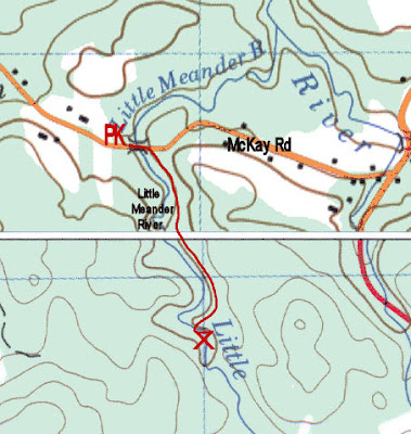
DIRECTIONS: from Windsor, take Exit4 from HWY1 01 ,
eastward towards Newport Corner. Follow this road 4.5km,
turning left onto HWY21 5, then turn right after 3.5km onto
McKay Road. Continue on this road 5.5km, until you come to the
bridge over the Little Meander River. Park before the bridge well
of the highway.
photo by Andrew Paul (2014)
Trail Description: walk down the hill and cross the bridge,
heading into the woods on the upstream side. Keeping to the top
of the ravine on the left hand side, there are a few game trails
that are easily followed as long as you keep the river
immediately to your right. When you approach the waterfalls,
you will have to make your way down the steep hill into the gully
to the base of the falls.
photo Sylvia Fisher (2010)
A nice set of falls, reminiscent of a miniature Niagara Falls, with
an inviting pool at its base. Fishing is reputed to be very good
here, with white and yellow perch, as well as small mouth bass
and fair sized brook trout. Definitely one to pack your fold-up rod
in the backpack for this hike.
photo by Melanie Haverstock (2014)
Another worthwhile stop on your travels locally, is a diversion up
Clayton McKay Rd, northbound 2km before you reach theparking for these falls, and a visit to Smileys Provincial Park, a full service campground, open
from late-June- late-September. This Provincial Park features an 86 site campground, picnic
areas, large playground, abundant walking trails, and a popular summertime swimming hole
under the bridge.


No comments:
Post a Comment