
MILLER LAKE FALLS
Fall River, Halifax Regional Municipality
N 44° 49.580 W 063° 35.1 88
20T E 453638 N 4963825

RIVER: Tillmann Brook
CLASS: cascade
SIZE: 1 5'
RATING: average (**1 /2)
TRAIL: none
DISTANCE: <1 00m
HIKING TIME: 1 0min
CONDITIONS: moderate
Geocache:GCX6YD
NS Atlas Page: 58/Z4
NS topo map: 01 1 D1 3
(Mount Uniacke)
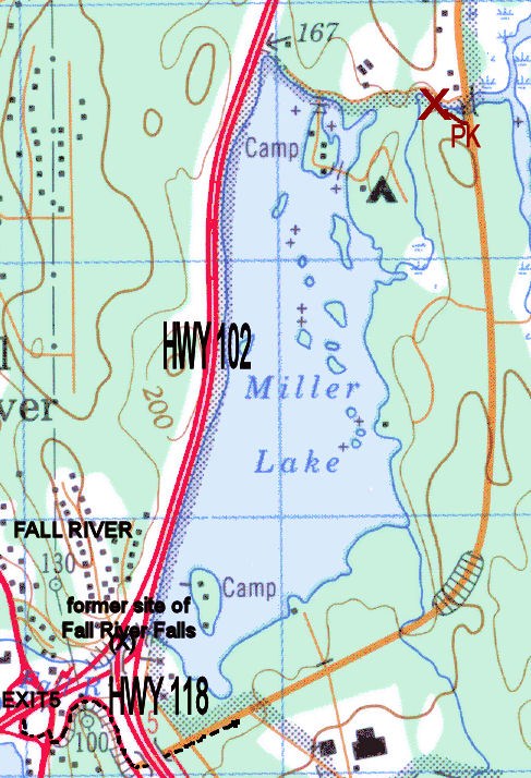
DIRECTIONS: from Halifax, drive north along HWY 1 02
(Veteran's Memorial Highway) and take Exit5 onto HWY2,
crossing straight across onto the ramp leading towards
HWY1 21 8. Turn left onto Guysborough Road, crossing
underneath the highway. Follow this road (which becomes Perrin
Drive) approximately 2km and park before the bridge over
Tillmann Brook.
Trail Description: follow the trail in on the left side of the road,
and down to the base of the falls. A nice set of falls, with high
cliffs opposite of the trail, they make a nice diversion away from
the city without having to go far. Near these falls location, on
Perrin Drive, formerly stood Rutherfords Inn which operated from
the 1 840s through to the 1 870s.
Situated within the Waverly Game Reserve, these falls are not
the ones that give the community of Fall River their name. Those
falls formerly existed on the stream that flowed out from Miller
Lake to Lake Thomas. They were used for supplying power to
mills in the late 1 9th century and for providing hydroelectic
power in the early 1 900s. They were demolished in the 1 950s
during construction of the Veteran's Memorial Highway, at that
time called the Bicentennial Highway. They were
located where the 4-lane expressway currently
runs up the hill from the crossing of Lake
Thomas to the interchange with Highway 1 1 8 at

No comments:
Post a Comment