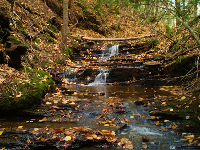
CURRY BROOK FALLS
West Brooklyn, Kings County
N 45° 08.508 W 064° 16.517
20T E 039961 9 N 4992087
RIVER: Curry Brook
CLASS: cascade
SIZE: 1 5'
RATING: excellent (***)
TRAIL: downstream
DISTANCE: 500km
HIKING TIME: 1 hour
CONDITIONS: moderate
NS Atlas Page: 47/X4
NS topo map: 021 H01 (Berwick)
DIRECTIONS: from Kentville, drive westward on HWY #1 01
(towards Windsor) and take Exit 9, onto Gaspereau River Road.
Drive eastward on this road approximately 3km, turning left onto
West Brooklyn Mountain Road. Drive up the mountain, about
2.5km, parking at the West Brooklyn Community Center.
Trail Description: walk to the back of the building and proceed
down the hill thru the field to the tree line. Watch for the
automobile graveyard in the alders, full of late fifties and early
sixties model vehicles. Make your way around the cars, to your
right, until you come to a small brook flowing downstream
towards Curry Brook. Either proceed along the high side of the
brook on the left hand side or walk down the stream.
There are several smaller falls along this tributary, ranging
between five to ten feet in height, which are very picturesque.
When you reach Curry Brook at the gut of the tributary stream,
turn downstream and proceed approximately 225 meters to the
falls.


No comments:
Post a Comment