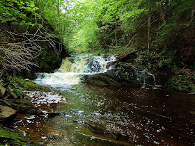
Minasville, Hants County
N 45° 17.045 W 063° 49.016
UTM: 20T E 435942 N 5014834
RIVER: Moose Brook
CLASS: steep cascades
SIZE: , 15',20'
RATING: average (***)
TRAIL: well used paths, some steep areas
DISTANCE: 150m
HIKING TIME: 15 minutes
CONDITIONS: moderate
Geocache: none
NS Atlas Page: 38/X5
NS topo map: 011E05 (Bass River)
DRIVING DIRECTIONS: from Windsor, take EXIT5 off HWY101 eastwards onto HWY14 East. Follow this road 8.6km to the village of Brooklyn. Turn left at the war memorial in the center of the road to remain on HWY14. Continue another 750m and continue straight thru onto HWY215 at the Petro Canada gas station. Continue another 1.0km and turn right onto HWY236 (signed for Stanley and Kennettcook). Drive 32.6km along this highway to the village of Kennettcook. Turn left to remain on HWY236 as it merges with HWY354 and continue 300m and take a slight left onto HWY354 (signed for Noel). Drive northward along this road 13.6km to its conclusion in Noel. Turn left onto HWY215 and drive 5.4km to the center of Minasville settlement. Turn left onto Old Road and park just past the mail boxes on your left side.
TOTAL DRIVING DISTANCE/TIME: 62km/55minutes

TRAIL DESCRIPTION: walk back to the bridge over Moose Brook on HWY215 and make your way down to the stream below. Upper Moose Brook Falls is directly below the bridge, a wide complicated cascade about 15' high. Continue downstream to the lower falls, about 150m away, which are approximately the same height, with a smaller fall ata the high tide mark.


Wow - great pictures! Do you know what type of flower that is? Looks like a type of Orchid.
ReplyDelete